Chapter 7
Kbal Spean – The Head Bridge lost into the forest
When I was planning my trip in Kampuchea, I decided to carefully schedule all my trip in a way to see first the main sites, and leave the smaller and farther ones for the last. In the last two days I had a chance to see many beautiful places. One of these is called “Kbal Spean”. This place isn't visited much as it's about 30 km distant from Siem Reap. While planning my trip to Kampuchea I found some interesting pictures, and I decided to learn more about it. The pictures were showing what looked like some dense forest and some kind of statues sunken into a riverbed. So, I searched for information and then I discovered that this place is named “Kbal Spean”, with means “The Head Bridge”, but this place is also known as “The Valley of a Thousand Linga”. Kbal Spean was discovered quite recently compared to the other monuments of the Angkor archaeological park. In fact, this place was discovered by the French researcher Jean Boulbet in 1969. In fact, he was doing some research in the area, when he met a local hermit. The hermit told Mr. Boulbet that he had something to show to him. So, the hermit lead Mr. Boulbet into the deep forest and showed him this mysterious place.
Unluckily, later came dark times in Kampuchea as shortly later was the rise of the “Khmer Rouge” party lead by Mr. Pol Pot, the so called “No. 1 Brother” of the party, but more like, the No 1 Psycho that managed the Cambodian Genocide, from 1975 to 1979 (under his command from 800.000 to 4.000.000 people were killed). After the rise and fall of the “Khmer Rouge” party, slowly Kampuchea tried to rise again on her feet, but the times were long, painful and slow. A cold war was still going on, minefields were scattered all around, and the people, the survivors were in deep poverty. It took long time before Angkor started to work again as an attraction, and much later the authorities included Kbal Spean as a place that could be visited. Now this place, even though it's quite far from Siem Reap can be easily visited. When I was in Siem Reap, I took a driver and I decided to go there.
Leaving Siem Reap, you can take two ways. One is on the street No. 6 toward Phnom Penh (the same that goes to Roluos) and then after 6 km, to take a crossing going to north (on the left of the street), and follow this street between rice fields and villages which names are known only by the native. On this street you'll meet two bigger villages. The first will be Phumi Pradak about 9 km from the first crossing, and then Phumi Khna about 12 km from Phumi Pradak. In Phumi Khna are quite famous the shops that sell fruit juice to the travellers. From Phumi Khma, you're still about 20 km from Kbal Spean. The second way, the easiest one, is through the archaeological park. You've first to make your way to the East Mebon. It rises where now is a crossway. You'll take the way going East, just in front of the gate of the East Mebon and you'll follow it until the first big crossing and then you'll take left heading to north. On this way, you'll skip Phumi Pradak and you'll find yourself about 10 km far from Phumi Khna.
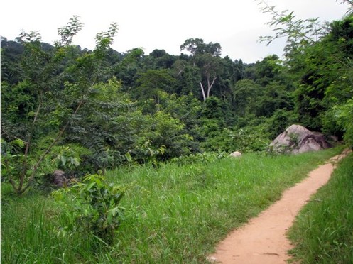
The street, just after the exit from the main part of the archaeological park turns into a long street of battered soil. You can't imagine what a nightmare it can turn into. Just there, a bit before Phumi Khna, the monsoon brought an heavy tropical storm on me. About 30 kilometres later, after a nightmarish ride on that motorbike driven by an unlicensed driver (I discovered it during that ride) the rain started to slow down, then it just poured and in the end it stopped. Soon later, through a muddy street we reached a soil parking lot. There was the starting point to Kbal Spean. I headed to the gate where a board said “Welcome to Kbal Spean you're 1.300 metres from it”. So, I headed on that way. I first went with quick steps. I was alone as the driver didn't follow me. I did some hundred metres before stopping. I chose a place that looked like it was safe and I had a rest. I took the water out of my boots and I studied the surroundings. The singing of the birds was the only sound of the place. Many colourful butterflies were flying around, and after some time, it was even pleasant to walk in the forest.
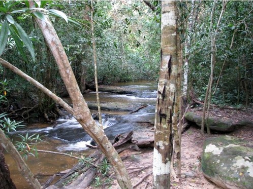
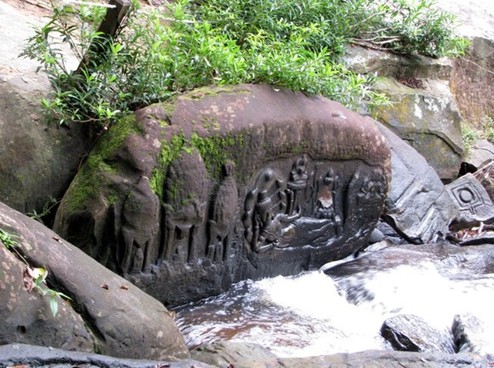
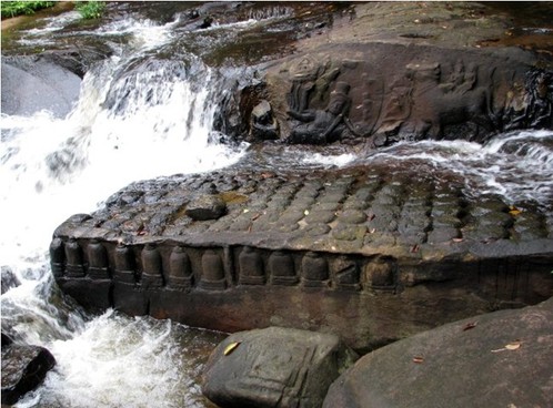
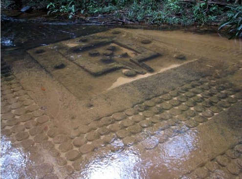
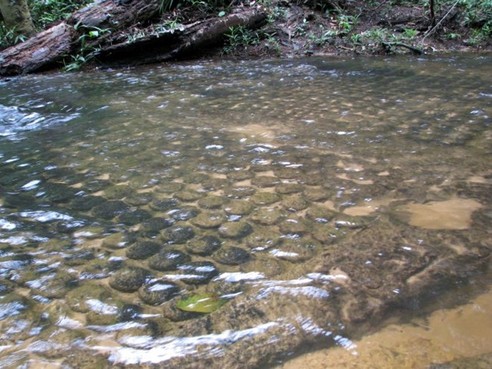
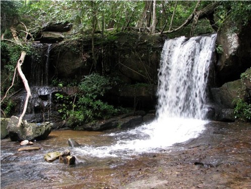
It took me some time to reach the site. First I met a river. I got past of it following a path, then a short way up the mountain, and then I met a second river. It looked just like a common river in a forest. So, I followed it upstream and then, all of a sudden, I’ve seen them. Many bas reliefs are carved into the riverbed. Most of them are Lingam, Lingam-Yoni and Hindu Deities. When I was there, I also heard female voices. I went to that direction, and I met two Japanese girls with a male guide. With the excuse of helping them to take some pictures, I stuck to them and we wandered around together. The place is really wonderful. So many carvings had been made into the riverbed and many more are just under the surface of the water, and they look like they are caressed by the river. This place is covered in mystery, and the scholars agree that this place must have been made by the Khmers to have an unlimited amount of holy water to fill the Baray reservoirs. When I was there I also discovered why this place is called “Head Bridge”. In fact, the river all of a sudden sinks under a rock shaped like a bridge and appears just after it with a very small waterfall. The carved part is about 200 metres long and it's really stirring, as strong feeling and the magical atmosphere surrounds you. I spent about half hour there and then I made my way back to the parking lot. On this way, I descended the riverbed again and this time I had the possibility to climb down a steep wall, with some wooden stairs. At the end of the wall, I had the occasion to see a beautiful small waterfall. From there, a short track took me back to the main one and then to the parking lot. Now, while going on the way back, I met many people that were going to see this place and I thought that it was good that I went there so early. When I reached the parking lot, it was already full of mini-vans and tuk-tuks. So, I reached my driver and I told him to go the way back. In fact, on the way back to Siem Reap there were still two places that were worth being seen.
Unluckily, later came dark times in Kampuchea as shortly later was the rise of the “Khmer Rouge” party lead by Mr. Pol Pot, the so called “No. 1 Brother” of the party, but more like, the No 1 Psycho that managed the Cambodian Genocide, from 1975 to 1979 (under his command from 800.000 to 4.000.000 people were killed). After the rise and fall of the “Khmer Rouge” party, slowly Kampuchea tried to rise again on her feet, but the times were long, painful and slow. A cold war was still going on, minefields were scattered all around, and the people, the survivors were in deep poverty. It took long time before Angkor started to work again as an attraction, and much later the authorities included Kbal Spean as a place that could be visited. Now this place, even though it's quite far from Siem Reap can be easily visited. When I was in Siem Reap, I took a driver and I decided to go there.
Leaving Siem Reap, you can take two ways. One is on the street No. 6 toward Phnom Penh (the same that goes to Roluos) and then after 6 km, to take a crossing going to north (on the left of the street), and follow this street between rice fields and villages which names are known only by the native. On this street you'll meet two bigger villages. The first will be Phumi Pradak about 9 km from the first crossing, and then Phumi Khna about 12 km from Phumi Pradak. In Phumi Khna are quite famous the shops that sell fruit juice to the travellers. From Phumi Khma, you're still about 20 km from Kbal Spean. The second way, the easiest one, is through the archaeological park. You've first to make your way to the East Mebon. It rises where now is a crossway. You'll take the way going East, just in front of the gate of the East Mebon and you'll follow it until the first big crossing and then you'll take left heading to north. On this way, you'll skip Phumi Pradak and you'll find yourself about 10 km far from Phumi Khna.
The street, just after the exit from the main part of the archaeological park turns into a long street of battered soil. You can't imagine what a nightmare it can turn into. Just there, a bit before Phumi Khna, the monsoon brought an heavy tropical storm on me. About 30 kilometres later, after a nightmarish ride on that motorbike driven by an unlicensed driver (I discovered it during that ride) the rain started to slow down, then it just poured and in the end it stopped. Soon later, through a muddy street we reached a soil parking lot. There was the starting point to Kbal Spean. I headed to the gate where a board said “Welcome to Kbal Spean you're 1.300 metres from it”. So, I headed on that way. I first went with quick steps. I was alone as the driver didn't follow me. I did some hundred metres before stopping. I chose a place that looked like it was safe and I had a rest. I took the water out of my boots and I studied the surroundings. The singing of the birds was the only sound of the place. Many colourful butterflies were flying around, and after some time, it was even pleasant to walk in the forest.
It took me some time to reach the site. First I met a river. I got past of it following a path, then a short way up the mountain, and then I met a second river. It looked just like a common river in a forest. So, I followed it upstream and then, all of a sudden, I’ve seen them. Many bas reliefs are carved into the riverbed. Most of them are Lingam, Lingam-Yoni and Hindu Deities. When I was there, I also heard female voices. I went to that direction, and I met two Japanese girls with a male guide. With the excuse of helping them to take some pictures, I stuck to them and we wandered around together. The place is really wonderful. So many carvings had been made into the riverbed and many more are just under the surface of the water, and they look like they are caressed by the river. This place is covered in mystery, and the scholars agree that this place must have been made by the Khmers to have an unlimited amount of holy water to fill the Baray reservoirs. When I was there I also discovered why this place is called “Head Bridge”. In fact, the river all of a sudden sinks under a rock shaped like a bridge and appears just after it with a very small waterfall. The carved part is about 200 metres long and it's really stirring, as strong feeling and the magical atmosphere surrounds you. I spent about half hour there and then I made my way back to the parking lot. On this way, I descended the riverbed again and this time I had the possibility to climb down a steep wall, with some wooden stairs. At the end of the wall, I had the occasion to see a beautiful small waterfall. From there, a short track took me back to the main one and then to the parking lot. Now, while going on the way back, I met many people that were going to see this place and I thought that it was good that I went there so early. When I reached the parking lot, it was already full of mini-vans and tuk-tuks. So, I reached my driver and I told him to go the way back. In fact, on the way back to Siem Reap there were still two places that were worth being seen.
Banteay Srey – The Women's Citadel
On the route that from Siem Reap goes north, you can see one of the most beautiful places in the whole archaeological park. This place is about 8 km distant from Phumi Khna, and which means about 35 km from the centre of Siem Reap. Usually this is the farthest place reached by the tourists, as it's uncommon that they go more north, unless they plan a tour up there, or they want to go to Kbal Spean.
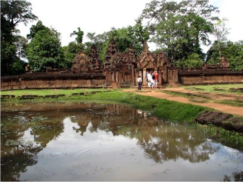
I reached this place on my way back from Kbal Spean. The sun now was clear in the sky, and after all the rain of the morning, the air was really humid and it felt much hotter than it was. Now when you reach Banteay Srey, you'll first see an huge souvenir market. I’ve never seen something like that. The shops extended all around the gate, and they channelled the flow of the people causing a bottleneck. To make matters worse, this is also one of the most visited places of the archaeological park, so it was very crowded. These days this site is defined worldwide as “a precious gem of the Khmer art”. I absolutely agree. The things that make this place so special are many. The first is the more obvious thing, I mean, that it's very beautiful. Then, this place is much more different than the others, as it's quite small and everything has a very strong symbolism. Here it looks like more value was given to the artwork than to the size. And the third thing, that is connected with the previous ones, is that this place had a different story than the other temples and citadels.
This place was built in the second half of the tenth century, in about 967 A.D.. This citadel is much smaller than the others for a main reason. In fact, the bigger ones were to show the power of the kings, but this one wasn't built by a king, but by a man. The name of this great man was Yajnavaraha, a man working close to the king Rajendravarman II. This man was famous for his philanthropic drive, and he built this citadel, both to help the people of this area (the walls were offering defence) and to give them also the chance to have temples where to pray and where to be cured too.
The building of Banteay Srey went on very well, and the following king, Jayavarman V finished the building and dedicated the temple to the Hindu God Shiva. The temple worked for many years, but with the fall of the Khmer empire this area went into oblivion too. The dense forest surrounded it and conquered it. The three vines silently embraced the abandoned palaces and the vegetation hid it as much as it could from the raiders. The place became lost and nobody knew about it for a long time. The raiders that came in the following centuries stole much of it, they damaged it badly, but still not much as it was far from the main streets and it was a real problem to bring away big pieces from it. The official discovery was made by Lieutenant Marec of the French geographic service, in 1914. The place was reported as being very beautiful, but it wasn't much taken in account for many years, as much of the funds were spent for the restoration of the bigger and more accessible temples.
Later in 1923 a French man called André Malraux, when he was in Kampuchea, heard about the beauty of Banteay Srey, and decided to visit it. When he reached the place, he was astonished by its beauty. Soon he decided that those bas reliefs showing girls of such a beauty were worth being put in some private collection than in being their own land, and, using a chainsaw, he took two of them and carried them away. Then, by fortune, he was intercepted when he was already at the border and arrested. The statues were taken back by the Khmers and Mr. Malraux, as French, didn't stand trial and was sent back to his country. Later he became Minister of French culture and later again fought in the resistance during the war. This incidence was as bad as it was good. In fact, besides the damage done by Mr. Malraux, now Banteay Srey came back to the eyes of the world, and it was chosen for a restoration campaign. The restoration campaign was led by that man of genius Mr. Marchal. He was chosen as he had already shown great skills, but now he faced a new challenge. It wasn't just to restore a common temple, but they had to restore the one with the most beautiful carvings. Moreover the temple was build with pink sandstone and it was very hard to work. So, he decided to use the anastylosis, a technique already used in Java. In this technique, the archaeologists should rebuild the missing parts copying the pattern of the neighbouring ones, using the same materials. The main problem that Mr. Marchal met on his way was that he had a local unskilled workforce, and he had to train them from scratch before letting them work on the real project. The hardest part was when he had to train the carvers to copy and replicate the carvings, as they are so delicate that they look like made in wood, rather than in solid rock. Mr. Marchal worked hard on it, and in the end, he did such a great work that it now can charm anybody that goes to visit it.
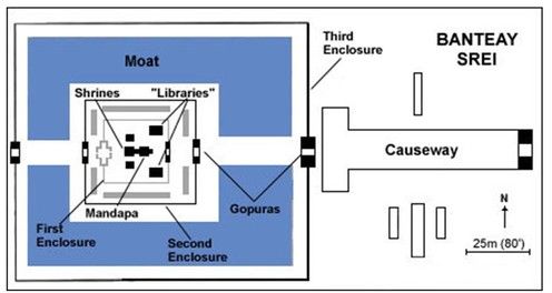
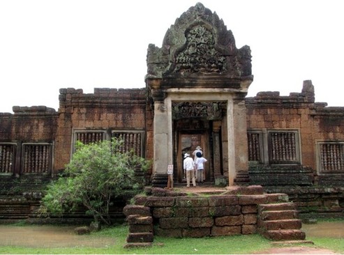
When you reach the place, you first find yourself on a street with rice fields on the both sides, then start the low walls of the citadel. As soon as the walls start, also starts the market. Many people are going to see this place every day, so it's suggested to go there in the early morning. The guards will check everybody for the entrance ticket and, if a large group is before you, it'll be a quite long wait before entering the site. While you’re there you'll even have the chance to observe the wonderful gate and its lintel. Already this lintel is a wonderful masterpiece the art of carving. It's very huge and both delicate and complicated, just like Banteay Srey is. As soon as you enter the gate, you'll find yourself on a causeway. On your sides some short columns will steer you toward the second enclosure, but your attention is engaged by what is surrounding you, and also by its colour. The entire Banteay Srey citadel was built in pink sandstone. All the other temples had usually been built in grey sandstone, but this one is pink, and looks more warm, more welcoming. On both sides of the causeway there are some small stone housings. You can visit them, but you have to be very careful not to step on the carving on the floor. The thing that looked more interesting to me, in these housings, was that most of them had first a regular, rectangular door, followed by another, a few metres later, shaped like an upside-down “V”.
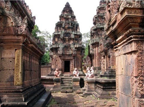
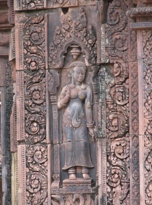
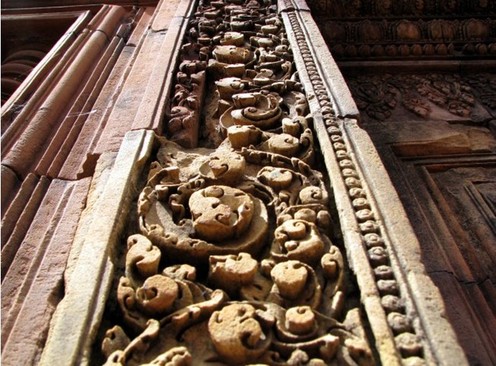
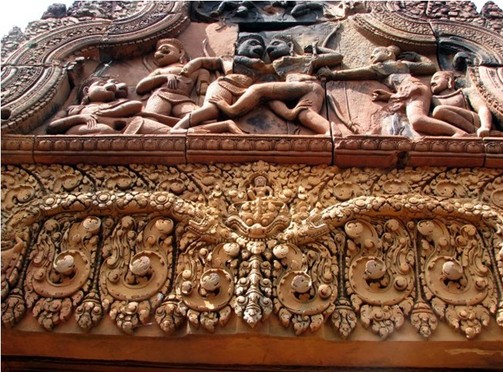
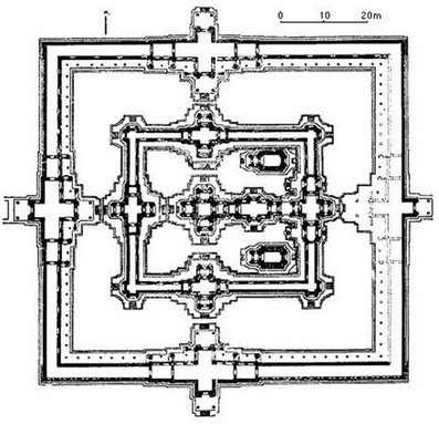
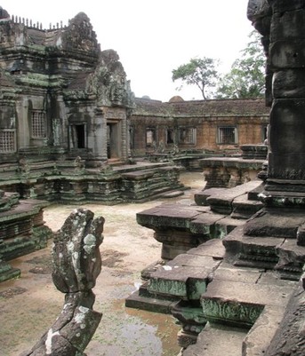
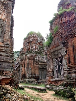
If you follow the causeway, you'll be led to the second wall line, and across it, you'll enter the second enclosure. This enclosure is an open space, where a moat, surrounded by a soil walkway, surrounds an artificial island. On the island some low walls surround the temples. Here everything has its own symbolism. The moat is the ocean, the walls that surround the temples are mountain chains, probably the Himalayas, while the central temples are the sacred Meru mountain. As you enter the second enclosure, you'll find yourself on a soil walkway that, looking like a bridge, will bring you straight to the gate in the walls of the temples, you can see it in the second picture of this group, on the opposite side, another gate and another walkway will bring you again out of the walls and across the moat. One more time, the temple is crossed from East to West, like a flow of the day, the flow of the life, or like a Naga snake churning the ocean of milk. Like the previous housings also the temples and the walls were built using pink sandstone. At this point the sun was really high in the sky and the sun was beating on my head like a hammer. So, without caring about looking a bit ridiculous, first I emptied a bottle on my head and then I wore my hat. It's a fabric hat in some kind of cowboy style. After this I headed toward the third enclosure. When I entered it, I found myself inside one of the most incredible places that I've ever been. Everything was carved so beautifully that I couldn't believe. Stone flowers were covering the walls, mythical creatures looked alive on the stones, and Devatas much different than those that I'd seen before, looked more human, and more sweet than ever. I think that everybody that goes there is in serious danger of falling in love with it. The central part is forbidden for the people, and you can't enter the very small temples. They are so small that the monks could only enter them crawling. Anyway the place is so small and cosy that you can see them from the fences and they are still close enough that you can't miss the smallest part. All of the place is wonderful, and the best parts are the lintels. These are the parts where the ancient Khmer workforce did its best. The most impressive is the use of the iconography of the ancient sea-monster Kirttimukha, also known with the name of Kala. This monster is represented by a head missing the lower jaw that swallows everything that surrounds it. The “everything” that is going to be swallowed often is shaped like two snakes that slither toward the mouth of Kala. You can see a lintel with Kala in the sixth picture. Usually Kala, in the Hindu religion, is connected with the destructive side of the God Shiva, as Kala is both meaning “black”, “time”, “death” and it’s also one of the names of Shiva. The scholars agree that the use of Kala comes from a far more ancient myth that preceded the coming of the Hindu religion to this area. Before it, the Khmers (Chenla and Fu-Nan people) were animists and believed in the spirits of nature. These ancient people had a bloody belief that, when they defeated an enemy, they should hang the enemy head outside their village as the enemy spirit would be bound to protect the village from other enemies. As time passed by, the heads turned into skulls and, as the tendons broke, they lost the lower jaw. So, the scholars say that Kala could be a more “modern” representation of the ancient skulls.
While searching for more information about, not Kampuchea, but about Burma, I found an interesting topic. First of all, while learning about the Khmers I found many times their belief that they were coming from the Nagas, the ancient snakes. But then, I discovered that, starting from Angkor, if you go north-west, you cross the border with Thailand, and then you go north, following the Mae Khong river. You'll reach the so called “Golden Triangle”, where Thailand, Laos and Burma touch each other, and where is the biggest traffic in Opium and Heroin. If you go still further north-west and you cross the Burmese border, you should find yourself in an area where many tribes live. They are mainly of Shan ethnicity, then Karen, Lisu and Akha. Among them, a big tribe is famous for being, until the 1960s a tribe of head hunters. They used to hang the heads of their enemies outside their village, as their spirit would protect the village from the other enemies. Their name, is Naga. I don't feel like I made a real discovery as many more expert people surely noticed it before me, but I think that it's still fascinating. It looks like that in south-east Asia, two so far apart populations had some ancestral connection.
Coming back to Banteay Srey, the visit of the temples of the third enclosure isn't very long as they are very small. You can walk in circle around them as many times as you wish before going away. While I was there I went around them many times, until the heat given out from the stone made scorching by the sun took away much of my strength. So, I went out of the third enclosure and went along the low walls toward the second enclosure, I crossed the moat, but instead of leaving the site, I followed the moat and sat in the shadow under a big tree. There, relaxing and drinking water, I enjoyed watching the ancient pink temples. Many colourful dragonflies, red and blue, were flying all around me. Some typical music was being played. Then came some wind. It brought the smell of the forest and of the rice fields, and with the waves of the music and the light of the sun, it painted a very beautiful picture. A picture called Banteay Srey. After some time enjoying the sight of Banteay Srey, I went back to my driver as I needed to go to see one more temple.
I reached this place on my way back from Kbal Spean. The sun now was clear in the sky, and after all the rain of the morning, the air was really humid and it felt much hotter than it was. Now when you reach Banteay Srey, you'll first see an huge souvenir market. I’ve never seen something like that. The shops extended all around the gate, and they channelled the flow of the people causing a bottleneck. To make matters worse, this is also one of the most visited places of the archaeological park, so it was very crowded. These days this site is defined worldwide as “a precious gem of the Khmer art”. I absolutely agree. The things that make this place so special are many. The first is the more obvious thing, I mean, that it's very beautiful. Then, this place is much more different than the others, as it's quite small and everything has a very strong symbolism. Here it looks like more value was given to the artwork than to the size. And the third thing, that is connected with the previous ones, is that this place had a different story than the other temples and citadels.
This place was built in the second half of the tenth century, in about 967 A.D.. This citadel is much smaller than the others for a main reason. In fact, the bigger ones were to show the power of the kings, but this one wasn't built by a king, but by a man. The name of this great man was Yajnavaraha, a man working close to the king Rajendravarman II. This man was famous for his philanthropic drive, and he built this citadel, both to help the people of this area (the walls were offering defence) and to give them also the chance to have temples where to pray and where to be cured too.
The building of Banteay Srey went on very well, and the following king, Jayavarman V finished the building and dedicated the temple to the Hindu God Shiva. The temple worked for many years, but with the fall of the Khmer empire this area went into oblivion too. The dense forest surrounded it and conquered it. The three vines silently embraced the abandoned palaces and the vegetation hid it as much as it could from the raiders. The place became lost and nobody knew about it for a long time. The raiders that came in the following centuries stole much of it, they damaged it badly, but still not much as it was far from the main streets and it was a real problem to bring away big pieces from it. The official discovery was made by Lieutenant Marec of the French geographic service, in 1914. The place was reported as being very beautiful, but it wasn't much taken in account for many years, as much of the funds were spent for the restoration of the bigger and more accessible temples.
Later in 1923 a French man called André Malraux, when he was in Kampuchea, heard about the beauty of Banteay Srey, and decided to visit it. When he reached the place, he was astonished by its beauty. Soon he decided that those bas reliefs showing girls of such a beauty were worth being put in some private collection than in being their own land, and, using a chainsaw, he took two of them and carried them away. Then, by fortune, he was intercepted when he was already at the border and arrested. The statues were taken back by the Khmers and Mr. Malraux, as French, didn't stand trial and was sent back to his country. Later he became Minister of French culture and later again fought in the resistance during the war. This incidence was as bad as it was good. In fact, besides the damage done by Mr. Malraux, now Banteay Srey came back to the eyes of the world, and it was chosen for a restoration campaign. The restoration campaign was led by that man of genius Mr. Marchal. He was chosen as he had already shown great skills, but now he faced a new challenge. It wasn't just to restore a common temple, but they had to restore the one with the most beautiful carvings. Moreover the temple was build with pink sandstone and it was very hard to work. So, he decided to use the anastylosis, a technique already used in Java. In this technique, the archaeologists should rebuild the missing parts copying the pattern of the neighbouring ones, using the same materials. The main problem that Mr. Marchal met on his way was that he had a local unskilled workforce, and he had to train them from scratch before letting them work on the real project. The hardest part was when he had to train the carvers to copy and replicate the carvings, as they are so delicate that they look like made in wood, rather than in solid rock. Mr. Marchal worked hard on it, and in the end, he did such a great work that it now can charm anybody that goes to visit it.
When you reach the place, you first find yourself on a street with rice fields on the both sides, then start the low walls of the citadel. As soon as the walls start, also starts the market. Many people are going to see this place every day, so it's suggested to go there in the early morning. The guards will check everybody for the entrance ticket and, if a large group is before you, it'll be a quite long wait before entering the site. While you’re there you'll even have the chance to observe the wonderful gate and its lintel. Already this lintel is a wonderful masterpiece the art of carving. It's very huge and both delicate and complicated, just like Banteay Srey is. As soon as you enter the gate, you'll find yourself on a causeway. On your sides some short columns will steer you toward the second enclosure, but your attention is engaged by what is surrounding you, and also by its colour. The entire Banteay Srey citadel was built in pink sandstone. All the other temples had usually been built in grey sandstone, but this one is pink, and looks more warm, more welcoming. On both sides of the causeway there are some small stone housings. You can visit them, but you have to be very careful not to step on the carving on the floor. The thing that looked more interesting to me, in these housings, was that most of them had first a regular, rectangular door, followed by another, a few metres later, shaped like an upside-down “V”.
If you follow the causeway, you'll be led to the second wall line, and across it, you'll enter the second enclosure. This enclosure is an open space, where a moat, surrounded by a soil walkway, surrounds an artificial island. On the island some low walls surround the temples. Here everything has its own symbolism. The moat is the ocean, the walls that surround the temples are mountain chains, probably the Himalayas, while the central temples are the sacred Meru mountain. As you enter the second enclosure, you'll find yourself on a soil walkway that, looking like a bridge, will bring you straight to the gate in the walls of the temples, you can see it in the second picture of this group, on the opposite side, another gate and another walkway will bring you again out of the walls and across the moat. One more time, the temple is crossed from East to West, like a flow of the day, the flow of the life, or like a Naga snake churning the ocean of milk. Like the previous housings also the temples and the walls were built using pink sandstone. At this point the sun was really high in the sky and the sun was beating on my head like a hammer. So, without caring about looking a bit ridiculous, first I emptied a bottle on my head and then I wore my hat. It's a fabric hat in some kind of cowboy style. After this I headed toward the third enclosure. When I entered it, I found myself inside one of the most incredible places that I've ever been. Everything was carved so beautifully that I couldn't believe. Stone flowers were covering the walls, mythical creatures looked alive on the stones, and Devatas much different than those that I'd seen before, looked more human, and more sweet than ever. I think that everybody that goes there is in serious danger of falling in love with it. The central part is forbidden for the people, and you can't enter the very small temples. They are so small that the monks could only enter them crawling. Anyway the place is so small and cosy that you can see them from the fences and they are still close enough that you can't miss the smallest part. All of the place is wonderful, and the best parts are the lintels. These are the parts where the ancient Khmer workforce did its best. The most impressive is the use of the iconography of the ancient sea-monster Kirttimukha, also known with the name of Kala. This monster is represented by a head missing the lower jaw that swallows everything that surrounds it. The “everything” that is going to be swallowed often is shaped like two snakes that slither toward the mouth of Kala. You can see a lintel with Kala in the sixth picture. Usually Kala, in the Hindu religion, is connected with the destructive side of the God Shiva, as Kala is both meaning “black”, “time”, “death” and it’s also one of the names of Shiva. The scholars agree that the use of Kala comes from a far more ancient myth that preceded the coming of the Hindu religion to this area. Before it, the Khmers (Chenla and Fu-Nan people) were animists and believed in the spirits of nature. These ancient people had a bloody belief that, when they defeated an enemy, they should hang the enemy head outside their village as the enemy spirit would be bound to protect the village from other enemies. As time passed by, the heads turned into skulls and, as the tendons broke, they lost the lower jaw. So, the scholars say that Kala could be a more “modern” representation of the ancient skulls.
While searching for more information about, not Kampuchea, but about Burma, I found an interesting topic. First of all, while learning about the Khmers I found many times their belief that they were coming from the Nagas, the ancient snakes. But then, I discovered that, starting from Angkor, if you go north-west, you cross the border with Thailand, and then you go north, following the Mae Khong river. You'll reach the so called “Golden Triangle”, where Thailand, Laos and Burma touch each other, and where is the biggest traffic in Opium and Heroin. If you go still further north-west and you cross the Burmese border, you should find yourself in an area where many tribes live. They are mainly of Shan ethnicity, then Karen, Lisu and Akha. Among them, a big tribe is famous for being, until the 1960s a tribe of head hunters. They used to hang the heads of their enemies outside their village, as their spirit would protect the village from the other enemies. Their name, is Naga. I don't feel like I made a real discovery as many more expert people surely noticed it before me, but I think that it's still fascinating. It looks like that in south-east Asia, two so far apart populations had some ancestral connection.
Coming back to Banteay Srey, the visit of the temples of the third enclosure isn't very long as they are very small. You can walk in circle around them as many times as you wish before going away. While I was there I went around them many times, until the heat given out from the stone made scorching by the sun took away much of my strength. So, I went out of the third enclosure and went along the low walls toward the second enclosure, I crossed the moat, but instead of leaving the site, I followed the moat and sat in the shadow under a big tree. There, relaxing and drinking water, I enjoyed watching the ancient pink temples. Many colourful dragonflies, red and blue, were flying all around me. Some typical music was being played. Then came some wind. It brought the smell of the forest and of the rice fields, and with the waves of the music and the light of the sun, it painted a very beautiful picture. A picture called Banteay Srey. After some time enjoying the sight of Banteay Srey, I went back to my driver as I needed to go to see one more temple.
Banteay Samre – The Samre's Citadel
The Banteay Samre citadel is quite near to the other monuments of the Angkor archaeological park, as it's in the south-east corner of the eastern Baray. In spite of this, the citadel is still suggested to be seen together with the outer places, like Kbal Spean and Banteay Srey. So, I followed this suggestion. I left Banteay Srey with the sun that was about to be covered again by the clouds. Form Banteay Srey we headed south. The street is quite straight and it crosses many small villages. On this long journey, I enjoyed the sight of the rice fields waving in the gentle hot breeze. People were living their ordinary life in the rice fields. Barefoot children were playing around, screaming and jumping in the water of the rice fields an that day many people were also fishing in the water channels around them, and it was interesting to see these sights. At the end of the long almost-straight street, you'll meet a cross way where you'll need to turn left, and later, the street will turn south (left again) following the banks of the ancient East Baray. When you reach the south-east corner of the Baray, you'll be very near to Banteay Samre. To reach Banteay Samre there are two main routes. Both of them, in the rainy season will be bad the same. In fact, after heavy rains, being that it is a land good only for the rice fields, you'll find all flooded. The walkway is made of soil, and after the rain of the previous night and morning, I had to walk toward the citadel with the water up to my ankles. I really didn't care much about it, as I was still drenched after the trip to Kbal Spean, so, in the end, I enjoyed also this narrow piece in the fields towards the citadel.
This place, named Banteay Samre, was built around the XII century, but the foundation of the city is surrounded by a haze of legend.
The Legend of King Pou
Once upon a time, there was a population living at the edge of the Angkor Thom that was called Samre. Among them, lived a man called Pou. This man was a farmer. Then, it happened that one day he received, in some supernatural way, some seeds of Sweet Cucumbers. He planted them, and from the seeds sprouted plants that gave wonderful cucumbers. He was so proud of his cucumbers that he gave the fruits of his first harvest to the king. The same king, impressed by the taste of the cucumbers, made an edict that gave to Mr. Pou the power to kill anything, man or animal that entered his “chamcar”, that means, his garden. Then it happened that in one of the following years, the rainy season lasted a very short time, and the monsoons didn't bring much water. This meant that the sweet cucumbers grew really slowly. The king that was really fond, or maybe even addicted to these cucumbers, decided to leave the court and go to the field of Mr. Pou to ask for the cucumbers. He reached the field at night, and Mr. Pou, not recognising him, thinking that he was somebody that wanted to steal his cucumbers, took his spear and killed the king. When he recognised the king, he was scared as hell. First he decided to hide the body, and he buried him inside the sweet cucumber field. But in no-time, everybody knew about the murder and he was sentenced to death. The same king, didn't have straight descendants, so, many people of the court claimed the throne for themselves. The situation was terrible, as the kingdom was without a guidance, and they had a murderer to kill. The court decided to make it is as fast as possible, so it was decided that, those that claimed the throne, would fight each other on the king's place of death, and the new king would kill Mr. Pou. As a prize for the winner would be also the king's sacred elephant, the one that could only be mounted by the real king. The court first retrieved the body of the king and made a proper funeral at the East Mebon. After, all the people gathered on the garden of Mr. Pou and he also was brought there waiting till his executioner was chosen. But then something supernatural happened again. As the elephant was brought there, it went berserk and dashed straight for Mr. Pou. Everybody probably thought that the elephant was looking for vengeance, but before stepping over Mr. Pou, it stopped and took him with its trunk. It lifted Mr. Pou from the ground and placed him on his back. The new king was chosen. Nobody could say anything against the choice of the sacred elephant. In this way, Mr. Pou became the new king. This didn't mean that an easy life started for him. In fact, most of the people working at the court didn't respect him. It happened that lots of people didn't follow his orders and others made fun of him. He couldn't stand this situation anymore, and he decided to build a new citadel near to his birthplace, where to reign surrounded by his people. Only the few faithful to him, followed the king to Banteay Samre. Now the king was far from the palaces, but the situation was getting worse and worse. To correct it, he decided to use the rough way. He made a new decree that said that anybody that didn't do whatever the king ordered or made fun of him, would be beheaded. With this menace, he gained again the control of the court. The years that followed in his kingdom were happy and wealthy. This is the legend about the king Pou.
I don't know how much is true in this tale, but the truth is that, in our days, Banteay Samre is a very beautiful and underestimated place to be seen.
When you reach Banteay Samre, you'll first be surprised on the thin-looking walls. They don't much look as if they were built to protect a king. Then, the other thing that will be noticed is that, like in other places like Angkor Wat, the doorways are about 1.5 metres above the ground. This means two things, first there wasn't the need to bring big amounts of goods inside and outside as ox-pulled carts could never pass through those doorways at about 1.5 metres from the ground, and the second thing, is that probably in those times this area was often flooded and this would prevent that too much water would get inside. You can approach to Banteay Samre from two sides, the north one and the west one. Probably the shorter is the north. I came from this side, and as soon as I got there, I saw that already from outside, the place looked very beautiful. While approaching the doorway, I saw that the stone steps were broken and people had to take care while climbing them. When you reach the doorway at 1.5 metres from the ground, you'll have to go through it to find yourself in the first enclosure. The walls aren't very thick and they also have many windows. The first enclosure is a garden that surrounds the second line of walls. This garden is about 1.5 metres below the doorways of the first and second walls lines. To reach the next doorway, you have to descend to the ground and climb again some steps to reach the next door.
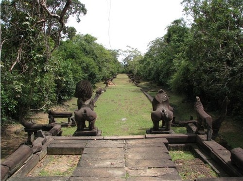
This time, the second line of walls, is made of a gallery that surrounds the core structures. In the places where the doorways are and on the sides the galleries start, there are some Lingam on the ground. Once this too is crossed, you'll enter the core area, and this is the best one. In fact, the core area is made of only few, very beautiful, stone housings, but they had also been made about 1.5 metres from the ground. They are surrounded by what could look like an ancient pool. I only suppose that in the ancient past this could symbolise the ocean while the housings could be the representation of the sacred mountains, but I'm not sure. Or maybe these were pools in which the water reflected the same housing, I mean, something like the pools inside Angkor Wat. The housings are very beautiful, and many pretty carving are all around. You can wander freely around and eventually exit through the doorways at the cardinal points. I decided to go to the east side, toward the direction where the sun rises. I had to again go through the doorway, the first enclosure and again the walls. I found myself on a lawn. I crossed it and I found something that looked like a pier standing on some columns. Two Singha lions were standing at the end of it. From the pier, about 1.5 metres below started a walkway toward east, heading toward nowhere, which sides were trailed by Naga snakes. You can see the pier and the walkway in the fifth picture of this group.
I spent some time relaxing there, then I decided to sit under an huge tree. I had just time to sit when I met another Cambodian animal, some big red, fat and pissed-off ants. They started to crawl on me and to bite me. I had no choice than to kill most of them while getting them away from me. After this unpleasant meeting, I went back to the citadel. I spent some more time there inside, looking at the Shivaite bas-relief showing the myths of the creation of the world. After some time, I went back to my driver. We went back to Siem Reap. When I reached the city, I told him to stop at the pub street. It was late afternoon, and in the distance were again building some big clouds. I entered my favourite pub, the “Easy Speaking” pub where I had my late lunch and an ice-cold draft beer. I loved that pub. It was so quiet, the food was wonderful and my favourite waiter Miss Pua, was always so kind and smiley. I relaxed there, chatting with Miss Pua and drinking that good beer. After that long and thrilling day, for the first time I felt again that I could sit back and relax.
This place, named Banteay Samre, was built around the XII century, but the foundation of the city is surrounded by a haze of legend.
The Legend of King Pou
Once upon a time, there was a population living at the edge of the Angkor Thom that was called Samre. Among them, lived a man called Pou. This man was a farmer. Then, it happened that one day he received, in some supernatural way, some seeds of Sweet Cucumbers. He planted them, and from the seeds sprouted plants that gave wonderful cucumbers. He was so proud of his cucumbers that he gave the fruits of his first harvest to the king. The same king, impressed by the taste of the cucumbers, made an edict that gave to Mr. Pou the power to kill anything, man or animal that entered his “chamcar”, that means, his garden. Then it happened that in one of the following years, the rainy season lasted a very short time, and the monsoons didn't bring much water. This meant that the sweet cucumbers grew really slowly. The king that was really fond, or maybe even addicted to these cucumbers, decided to leave the court and go to the field of Mr. Pou to ask for the cucumbers. He reached the field at night, and Mr. Pou, not recognising him, thinking that he was somebody that wanted to steal his cucumbers, took his spear and killed the king. When he recognised the king, he was scared as hell. First he decided to hide the body, and he buried him inside the sweet cucumber field. But in no-time, everybody knew about the murder and he was sentenced to death. The same king, didn't have straight descendants, so, many people of the court claimed the throne for themselves. The situation was terrible, as the kingdom was without a guidance, and they had a murderer to kill. The court decided to make it is as fast as possible, so it was decided that, those that claimed the throne, would fight each other on the king's place of death, and the new king would kill Mr. Pou. As a prize for the winner would be also the king's sacred elephant, the one that could only be mounted by the real king. The court first retrieved the body of the king and made a proper funeral at the East Mebon. After, all the people gathered on the garden of Mr. Pou and he also was brought there waiting till his executioner was chosen. But then something supernatural happened again. As the elephant was brought there, it went berserk and dashed straight for Mr. Pou. Everybody probably thought that the elephant was looking for vengeance, but before stepping over Mr. Pou, it stopped and took him with its trunk. It lifted Mr. Pou from the ground and placed him on his back. The new king was chosen. Nobody could say anything against the choice of the sacred elephant. In this way, Mr. Pou became the new king. This didn't mean that an easy life started for him. In fact, most of the people working at the court didn't respect him. It happened that lots of people didn't follow his orders and others made fun of him. He couldn't stand this situation anymore, and he decided to build a new citadel near to his birthplace, where to reign surrounded by his people. Only the few faithful to him, followed the king to Banteay Samre. Now the king was far from the palaces, but the situation was getting worse and worse. To correct it, he decided to use the rough way. He made a new decree that said that anybody that didn't do whatever the king ordered or made fun of him, would be beheaded. With this menace, he gained again the control of the court. The years that followed in his kingdom were happy and wealthy. This is the legend about the king Pou.
I don't know how much is true in this tale, but the truth is that, in our days, Banteay Samre is a very beautiful and underestimated place to be seen.
When you reach Banteay Samre, you'll first be surprised on the thin-looking walls. They don't much look as if they were built to protect a king. Then, the other thing that will be noticed is that, like in other places like Angkor Wat, the doorways are about 1.5 metres above the ground. This means two things, first there wasn't the need to bring big amounts of goods inside and outside as ox-pulled carts could never pass through those doorways at about 1.5 metres from the ground, and the second thing, is that probably in those times this area was often flooded and this would prevent that too much water would get inside. You can approach to Banteay Samre from two sides, the north one and the west one. Probably the shorter is the north. I came from this side, and as soon as I got there, I saw that already from outside, the place looked very beautiful. While approaching the doorway, I saw that the stone steps were broken and people had to take care while climbing them. When you reach the doorway at 1.5 metres from the ground, you'll have to go through it to find yourself in the first enclosure. The walls aren't very thick and they also have many windows. The first enclosure is a garden that surrounds the second line of walls. This garden is about 1.5 metres below the doorways of the first and second walls lines. To reach the next doorway, you have to descend to the ground and climb again some steps to reach the next door.
This time, the second line of walls, is made of a gallery that surrounds the core structures. In the places where the doorways are and on the sides the galleries start, there are some Lingam on the ground. Once this too is crossed, you'll enter the core area, and this is the best one. In fact, the core area is made of only few, very beautiful, stone housings, but they had also been made about 1.5 metres from the ground. They are surrounded by what could look like an ancient pool. I only suppose that in the ancient past this could symbolise the ocean while the housings could be the representation of the sacred mountains, but I'm not sure. Or maybe these were pools in which the water reflected the same housing, I mean, something like the pools inside Angkor Wat. The housings are very beautiful, and many pretty carving are all around. You can wander freely around and eventually exit through the doorways at the cardinal points. I decided to go to the east side, toward the direction where the sun rises. I had to again go through the doorway, the first enclosure and again the walls. I found myself on a lawn. I crossed it and I found something that looked like a pier standing on some columns. Two Singha lions were standing at the end of it. From the pier, about 1.5 metres below started a walkway toward east, heading toward nowhere, which sides were trailed by Naga snakes. You can see the pier and the walkway in the fifth picture of this group.
I spent some time relaxing there, then I decided to sit under an huge tree. I had just time to sit when I met another Cambodian animal, some big red, fat and pissed-off ants. They started to crawl on me and to bite me. I had no choice than to kill most of them while getting them away from me. After this unpleasant meeting, I went back to the citadel. I spent some more time there inside, looking at the Shivaite bas-relief showing the myths of the creation of the world. After some time, I went back to my driver. We went back to Siem Reap. When I reached the city, I told him to stop at the pub street. It was late afternoon, and in the distance were again building some big clouds. I entered my favourite pub, the “Easy Speaking” pub where I had my late lunch and an ice-cold draft beer. I loved that pub. It was so quiet, the food was wonderful and my favourite waiter Miss Pua, was always so kind and smiley. I relaxed there, chatting with Miss Pua and drinking that good beer. After that long and thrilling day, for the first time I felt again that I could sit back and relax.
The street to Rolous - When I witnessed the birth of a peace
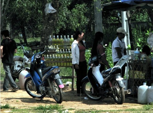
When I was in Siem Reap, usually I got back from my trips around the temple at around 16.00-17.00. So, one day, after a late lunch, I decided to take a driver and to go to the near Rolous to see the most ancient temples of this area. So, after my lunch in the Pub Street, I had a short walk and then I stopped a lonely driver and I bargained with him to go to Rolous and back. It took a very short time, and soon we were going toward Rolous with his Tuk-Tuk. While going there I noticed that on the sides of the streets there were many small shops selling bottles of something yellowish (you can see it in the first picture from this group). I wondered if it was some kind of juice or alcohol, so I asked to the driver what it was, and he told me that it was gasoline. In fact, only now I noticed that I only seen one gasoline station since my arrival in Kampuchea. Again, when I have shown this picture to my friends, only one guessed right, as the others thought that it was some kind of juice shop.
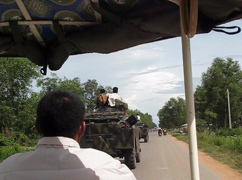
While going to Rolous we met a columns of tanks loaded with soldiers (you can see them in the second picture of this group). Just few days before going there, I'd read in a newspaper that there was a fight between Thailand and Kampuchea in a place called Preah Vihar. The two nations were close to a war. They even had a battle there in those days. While going there, I even planned at least four escape routes in case of war. All toward Thailand or Vietnam. So, when I was there and I saw the tanks, I got afraid that it'd turn into a real large-scale war. I asked my driver, worried, what had happened, and he answered that "the war was over", the tanks were coming back to their bases. That was a great news. This meant, that the two nations chose the peace instead of the weapons. I wondered, when I was there, if I had witnessed the birth of a new (I hoped a long lasting) peace. A few months later a new battle started.
While going to Rolous we met a columns of tanks loaded with soldiers (you can see them in the second picture of this group). Just few days before going there, I'd read in a newspaper that there was a fight between Thailand and Kampuchea in a place called Preah Vihar. The two nations were close to a war. They even had a battle there in those days. While going there, I even planned at least four escape routes in case of war. All toward Thailand or Vietnam. So, when I was there and I saw the tanks, I got afraid that it'd turn into a real large-scale war. I asked my driver, worried, what had happened, and he answered that "the war was over", the tanks were coming back to their bases. That was a great news. This meant, that the two nations chose the peace instead of the weapons. I wondered, when I was there, if I had witnessed the birth of a new (I hoped a long lasting) peace. A few months later a new battle started.
Rolous - Lolei - The island that witnessed a genocide
The name of Lolei had attracted me since the beginning of my research about Kampuchea. The truth may lie under its name as I find it so melodious. The first pictures that I've found about it were about some old towers over which were growing wild plants (like the one in the second picture of this group). In the beginning I imagined the place as a secret cluster of ancient tower-temples hidden in the deep forest. In spite of that, I soon learnt that it was in the middle of a small village, on a side of the main street that goes from Phnom Penh to Siem Reap.
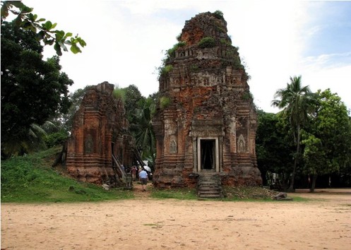
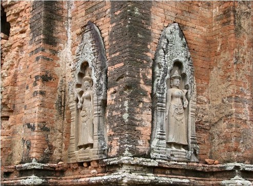
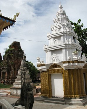
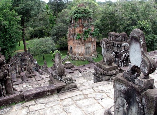
The history of this place is both interesting and really touching. In fact, when the first Khmers came to the Tonle Sap lake shores, when they had to set a new capital city up, they chose the area that now is known as Rolous. In this area they founded the city of Hariharalaya. As the new city needed a water reservoir, the king Indravarman I decided to build at the north of the city an artificial lake (a Baray). Like as happened later in the Angkor times, in the lake was built an artificial island (called Mebon). The king Yasovarman in the 893 A.D. decided to build on the artificial island the Lolei temple, as a tribute to his predecessor, the king Indravarman I and the God Shiva. In our days the Baray is totally dried and now its place has been taken by the rice fields. When you reach Lolei, you see first a small parking lot with high trees between some low houses. From the parking lot there is a short stairway that will lead you up a small hill about 4-5 metres high. Once you reach the top of the small hill, you'll find a large square before you. On my right, on the side of the square there was a small house that I supposed to be some kind of a school. On my left, there was a very small white and gold painted Stupa, you can see it in the fourth picture, and behind of it, a modern Buddhist temple. Crossing the rectangular square, still on your left, just after the temple, you'll meet the towers of Lolei. There are six brick and stone towers. When you're there you'll notice that they are absolutely in ruin and they also look in danger of collapsing from one moment to the next. The towers are of different sizes, the front three are bigger, while the back ones are smaller. On the towers, above the doorposts, you can find some Sanskrit inscriptions. According to one of these inscriptions, it looks like Yasovarman I dedicated four of these towers to his mother, his father and his maternal grandparents on the 12th July 893 A.D.. As I wrote, the more than 1000 years old towers are in very poor condition and the carvings are barely recognisable. As you can see in the pictures, the best parts are the lintels and some bas-reliefs representing Devatas and Deities.
This place, had still a very tragic role in the recent history of Kampuchea. In fact in the time between the 1975 and 1980 the "Khmer Rouge" dictatorship lead a massacre against their own population. Anybody that didn't match in their foolish plans were worth being tortured and killed. Those that were for the free market economy were killed, the teachers were killed, people wearing glasses as they may look like intellectuals, were also killed. The genocide has terrible numbers. Nobody knows the exact number of the killings, but the scholars say that the number is between 800.000 to 4.5 million people depending on who did the counting. The main killing field was in Phnom Penh, a school turned in to a massacre unit, where, when it rains in our days, human bones still come out from the soil of the ground. But there were other killing fields. One of these killing fields was there, at Lolei, before the ancient towers. I couldn't stop thinking of the people killed there, and an heavy sadness fell over me. The beauty of the place, stained with the blood of the victims of the genocide, gave me opposing feelings. So, after a respectful "See you again" to the towers, I went to my driver and we went to the next temple.
Roluos - Preah Ko - The Sacred Ox temple
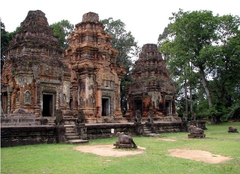
The second of the three main temples of the Rolous group is the Preah Ko temple. There are some more temples scattered around, but, most of them, in spite of the name "temple" aren't more than pieces of walls in ruin. So, the Rolous group is known as being made of only three temples. When you reach this temple, you'll first notice that it looks really similar to the Lolei temple. The two main differences are that it's not on a kind of hill, and it's better preserved. In fact, the walls of some ancient housings, around it, are still there, while those around Lolei disappeared through the centuries.
The temple is called of the "Sacred Ox" for the three Ox statues standing before the three main towers. This place was built in 879 A.D. by the king Indravarman I, and it's dedicated to the God Shiva, to the predecessor of the king (that was king Jayavarman II) and to the ancestors of the king Indravarman I. The first line of the towers was dedicated to the Gods, corresponding to the male ancestors of the king, while the second line was dedicated to the Goddesses corresponding to the female ancestors. A stele that was found perfectly preserved on the entrance for this site eulogies king Indravarman I when he was still a prince with these words "the right arm of the prince is long, strong, and fearsome in battle as his flashing sword falls on his enemies, defeating kings in every direction. Invincible, he can be appeased by two enemies only - those who have their backs turned, and those who, valuing life, put themselves under his protection" (translation by Mr. G. Cœdes). The tour of this site can be very short as most of it is in ruins. From the map, like for other sites, it looks like many buildings are left to be seen, but, in the reality, for the most of them, you can just see the plan of the building as low pieces of walls on the ground. The best preserved parts are the towers that you can see in the picture. The visit of this site, like for the Lolei temple, may take only about 15 minutes, unless you are interested to see all the well displayed piles of stones around.
The temple is called of the "Sacred Ox" for the three Ox statues standing before the three main towers. This place was built in 879 A.D. by the king Indravarman I, and it's dedicated to the God Shiva, to the predecessor of the king (that was king Jayavarman II) and to the ancestors of the king Indravarman I. The first line of the towers was dedicated to the Gods, corresponding to the male ancestors of the king, while the second line was dedicated to the Goddesses corresponding to the female ancestors. A stele that was found perfectly preserved on the entrance for this site eulogies king Indravarman I when he was still a prince with these words "the right arm of the prince is long, strong, and fearsome in battle as his flashing sword falls on his enemies, defeating kings in every direction. Invincible, he can be appeased by two enemies only - those who have their backs turned, and those who, valuing life, put themselves under his protection" (translation by Mr. G. Cœdes). The tour of this site can be very short as most of it is in ruins. From the map, like for other sites, it looks like many buildings are left to be seen, but, in the reality, for the most of them, you can just see the plan of the building as low pieces of walls on the ground. The best preserved parts are the towers that you can see in the picture. The visit of this site, like for the Lolei temple, may take only about 15 minutes, unless you are interested to see all the well displayed piles of stones around.
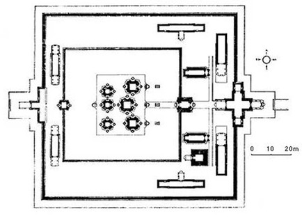
Roluos - Bakong Temple - The stone house of Isa
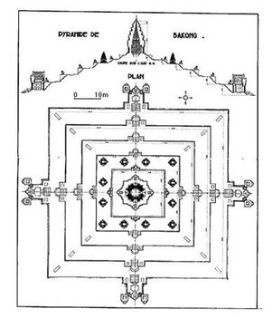
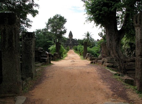
The biggest temple of the Rolous group is the Bakong temple. It's quite near to the Preah Ko temple, but it's totally different. The construction of the temple started in 881 under the kingdom of Indravarman I. The mountain-temple represent the sacred Meru mountain. The temple was discovered in 1936 by Hery Marchal and was restored stone-by-stone. Now the temple has an astonishing aura, as also a moat surrounds it. When you reach this place, you can feel like an ancient explorer, as the temple looks like it’s lost in the jungle. In the beginning, when you reach the place, you can't see it. You first have to climb a short stairway, but then, as long as you go through the bridge over the moat, you'll see the temple appear from afar, and it's just beautiful. The ancient pyramid stands proud in its over 1000 years beauty. It's charming and majestic. The large plan of the pyramid and the high tower on the top, makes it look like the tower itself would be a Lotus flower. This temple was built by the King Indravarman I and a stele found at the base of the temple remarks that the king called this place "The stone house of Isa", as to remark that it was his own home. In the same stele was also recorded that the temple was dedicated to the God Shiva, and were even recorded the beginning of the works for the "Indratataka", and the Baray where was also built the Lolei temple.
When I visited the place, it was cloudy and it looked like it could start to rain very soon. Anyway, I climbed the pyramid to the top. From there, a very sweet sense of quiet came to me. I was the only tourist there, and it was very pleasant to sit for a short time to look at the temple and to the forest around of it. Many Singha lions were guarding the ageless empty stairways, and the sounds of the forest, the wind, far thunders and the singing birds were the only sounds around me. It was lovely to be there. One more thing that made this temple so very important is that, this temple, means a great deal also for Khmer architecture, as many other temples were inspired by this, first of all, the Phnom Bakeng temple. In fact, the kings lived in the city of Hariharalaya for about 60 years only. Then, after the continuous floods, they decided to move the capital city, and settled the new city where is the Angkor that we can see now. To keep a connection, their first temple in the Angkor area was the Phnom Bakeng temple, that was built as much as they could, to make it look like the Bakong temple.
The light went down quite fast, and I decided to leave the place in time to make it all the way back to Siem Reap with still the sun light. I reached Siem Reap when it was starting to rain, and now it was time to rest some time before heading out to have a dinner with the tasty Khmer food.
