Travel to Cambodia and Thailand 2008
Before getting things started...
I want to make some advertisement. In fact, most of the planning of my Cambodian trip was done thanks to the books "Cambogia - Footprint Editions", "Cambogia - Polaris Editions", "A record of Cambodia - by Zhou Daguan translated by Peter Harris", Wikipedia (www.it.wikipedia.org), The Angkor Guide by Maurice Glaize (www.theangkorguide.com/index.html) from where all the maps of the temples are coming from, and the website of the organization that cares to the Archaeological park the "APSARA authority" (www.autoriteapsara.org). For the trip in Thailand most of the information were gathered in the book “Thailandia – Lonely Planet”, Wikipedia (www.it.wikipedia.org) and some forums too. The hotel bookings were made thanks to the websites Tripadvisor (www.tripadvisor.com), Asia Rooms (www.asiarooms.com), Hotel Thailand (www.hotelthailand.com). All the information gathered from these sources allowed me to plan a wonderful trip, and I'm grateful to all those that worked behind the scenes these sources.
Time to getting the things started.
Kampuchea - The Land of the sons of Kampu
This voyage started the 25th of October 2008. I left Genova with a pullman to Milan. From Milan I took off with a plane in the afternoon heading, first Doha in Qatar, then Bangkok in Thailand and then Siem Reap, Cambodia. In spite, this could look like a long way to reach Cambodia, it was just a small part of the voyage. In fact, this voyage started a long way before. It wasn't three months before, when I started to plan everything down, but several years ago. In fact, many years ago (over ten years now), I was looking at a website, when I found some very interesting pictures of the Angkor archaeological park. Since then, I started to be very interested about it. All the times that I found some information about it, for me, was always a great pleasure to learn something more. Of course, as for any far away trip, also this one needed good preparation, and somebody to travel with. So, it took to me many years before feeling that it was a good moment to go. I should also say that, one of the main reasons that slowed my decision, was that in 1980s in Cambodia was a Dictatorship that caused a genocide. The land was packed with minefields and the extreme poverty didn't make Cambodia a safe place at all, for many following years.
But times changed, and international cooperation helped the land to get up from misery caused by the dictator Pol Pot and his gang. So, the wounds of the nation started to heal, even if deep scars are still visible everywhere. So, this year, I decided that it was the right moment to go, and I started to plan it. I studied hard all the books that I named before and I surfed the web to look which places were worth seeing and which were to keep as far away from as possible. Among all this information, and interesting tips about the temples and places, there were some things that I liked to learn more than the others. One of these was that the name "Cambodia" is a name used only by "us" Westerners. In fact, in the South East Asia, Cambodia is called Kampucha or Kampuchea. Many times I named the word "Cambodia" and people were looking at me like I said some meaningless word, but when I said "Kampuchea" everybody knew what I meant. The Kampuchean people also don't call themselves as "Cambodian", but as Khmer people (the Khmers pronounce the word Khmer something like "Kh-Mer"). So, for the deep respect that I feel toward them, in my travel diary I'll call Cambodia as Kampuchea and its people as Khmers. These names are coming from the Pali language (a very old and still used Indian language). The word Kapucha means something like "The land of the descendants of Kampu", as following what a legend tell, Kampu was the name of the ascetic that for first discovered this land. The name Khmer comes from the word "Khemara" that means "the pleasure of peace" or "the lands that please in happiness and peace", so the Khmers are the inhabitants of the land of happiness. I'm only sorry that for all its history, beside short times of peace, the land was always torn with wars and soaked in blood. But the power of these people, is to keep on smiling in spite of all that happened, and keep on looking forward trying to recover from their own past. Anyway, Kampuchea is a very poor country, and everybody will do anything to gain something from you. It's quite unlikely that you'll be stolen from or victim of a crime, unless you do something irresponsible and you seek danger. But these people will try to do business and, if they can, to take advantage of you. I don't find them guilty for this, seeing as most of the Khmer are living in poverty, I think that anybody would do the same in their shoes. So, I don't blame them for being pushy and sometimes irritating. It's just survival. Even if sometimes they are also scammers, and I didn't like that at all. Most of the times it happened with the tuk-tuk drivers. So, it was good that I planned exactly what I wanted to see, so they couldn't cheat me. In addition, they often say that if you hire them as your tuk-tuk driver, they could also be your guide, but it's a scam. A driver can't be a guide as it's forbidden by the Archaeological park rules. If you need a guide you have to hire an authorized one. But I studied all that I needed from my books, and, by good luck, I didn't need a guide (especially because I'd have to pay a guide 25 US Dollars per day, and it'd be too much). Anyway, I never had big problems with the Khmer people, not much more than I had in all the other places that I have visited.
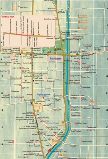
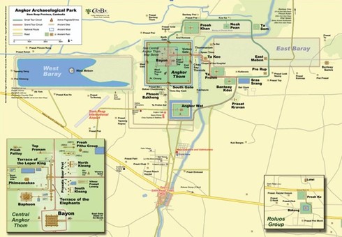
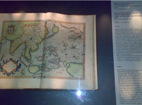
In this group of pictures you can see, first the map of the small city of Siem Reap (the red rectangle on the lower part, in Pokambor Avenue, marks my hotel), and then a map of the main part of the Angkor archaeological park. Just to give you an idea of the size, you can see that in the left-hand side of the map there's a gray line that marks the airport. You can see how many times you can fit the airport inside the park, as much as the very airport was built inside the park itself. The Angkor area, sometimes, in the documentaries and some "archaeological-fiction" publications, is called with names like "the forgotten Angkor", "the lost city of Angkor", all names that make you think of Angkor like a place lost through the tides of the time, hidden by the mist of mystery. It's not true. In fact, in spite of that most of the temples were abandoned and then swallowed by the dense jungle, it was always known that they were there. The honour of the "discovery" of Angkor was given to Mr. Heri Mahout in 1860. As in his journey through the South East Asia, he visited the shores of the lake Tonle Sap and the villagers shown him some of the temples. When he went back to France, he published a travel diary that soon became a best-seller. We should still say "Thank You" to Mr. Mahout, as after his work, the Angkor area gained a new life. In addition, the Tonle Sap area was already well known and already well charted in 1500, as you can see in the map (from 1500), in the third picture of this group. I found this map in the "Galata Sea Museum" of Genova. Of course, the geography of that time has many mistakes, but you can see very well in the north of Thailand a dark mark, as it's the Tonle Sap Lake, where is also Angkor. So, now it's also the time, for us, to start our trip and see those interesting places ourselves.
But times changed, and international cooperation helped the land to get up from misery caused by the dictator Pol Pot and his gang. So, the wounds of the nation started to heal, even if deep scars are still visible everywhere. So, this year, I decided that it was the right moment to go, and I started to plan it. I studied hard all the books that I named before and I surfed the web to look which places were worth seeing and which were to keep as far away from as possible. Among all this information, and interesting tips about the temples and places, there were some things that I liked to learn more than the others. One of these was that the name "Cambodia" is a name used only by "us" Westerners. In fact, in the South East Asia, Cambodia is called Kampucha or Kampuchea. Many times I named the word "Cambodia" and people were looking at me like I said some meaningless word, but when I said "Kampuchea" everybody knew what I meant. The Kampuchean people also don't call themselves as "Cambodian", but as Khmer people (the Khmers pronounce the word Khmer something like "Kh-Mer"). So, for the deep respect that I feel toward them, in my travel diary I'll call Cambodia as Kampuchea and its people as Khmers. These names are coming from the Pali language (a very old and still used Indian language). The word Kapucha means something like "The land of the descendants of Kampu", as following what a legend tell, Kampu was the name of the ascetic that for first discovered this land. The name Khmer comes from the word "Khemara" that means "the pleasure of peace" or "the lands that please in happiness and peace", so the Khmers are the inhabitants of the land of happiness. I'm only sorry that for all its history, beside short times of peace, the land was always torn with wars and soaked in blood. But the power of these people, is to keep on smiling in spite of all that happened, and keep on looking forward trying to recover from their own past. Anyway, Kampuchea is a very poor country, and everybody will do anything to gain something from you. It's quite unlikely that you'll be stolen from or victim of a crime, unless you do something irresponsible and you seek danger. But these people will try to do business and, if they can, to take advantage of you. I don't find them guilty for this, seeing as most of the Khmer are living in poverty, I think that anybody would do the same in their shoes. So, I don't blame them for being pushy and sometimes irritating. It's just survival. Even if sometimes they are also scammers, and I didn't like that at all. Most of the times it happened with the tuk-tuk drivers. So, it was good that I planned exactly what I wanted to see, so they couldn't cheat me. In addition, they often say that if you hire them as your tuk-tuk driver, they could also be your guide, but it's a scam. A driver can't be a guide as it's forbidden by the Archaeological park rules. If you need a guide you have to hire an authorized one. But I studied all that I needed from my books, and, by good luck, I didn't need a guide (especially because I'd have to pay a guide 25 US Dollars per day, and it'd be too much). Anyway, I never had big problems with the Khmer people, not much more than I had in all the other places that I have visited.
In this group of pictures you can see, first the map of the small city of Siem Reap (the red rectangle on the lower part, in Pokambor Avenue, marks my hotel), and then a map of the main part of the Angkor archaeological park. Just to give you an idea of the size, you can see that in the left-hand side of the map there's a gray line that marks the airport. You can see how many times you can fit the airport inside the park, as much as the very airport was built inside the park itself. The Angkor area, sometimes, in the documentaries and some "archaeological-fiction" publications, is called with names like "the forgotten Angkor", "the lost city of Angkor", all names that make you think of Angkor like a place lost through the tides of the time, hidden by the mist of mystery. It's not true. In fact, in spite of that most of the temples were abandoned and then swallowed by the dense jungle, it was always known that they were there. The honour of the "discovery" of Angkor was given to Mr. Heri Mahout in 1860. As in his journey through the South East Asia, he visited the shores of the lake Tonle Sap and the villagers shown him some of the temples. When he went back to France, he published a travel diary that soon became a best-seller. We should still say "Thank You" to Mr. Mahout, as after his work, the Angkor area gained a new life. In addition, the Tonle Sap area was already well known and already well charted in 1500, as you can see in the map (from 1500), in the third picture of this group. I found this map in the "Galata Sea Museum" of Genova. Of course, the geography of that time has many mistakes, but you can see very well in the north of Thailand a dark mark, as it's the Tonle Sap Lake, where is also Angkor. So, now it's also the time, for us, to start our trip and see those interesting places ourselves.
Kampuchea - Siem Reap - The Lying down Siam
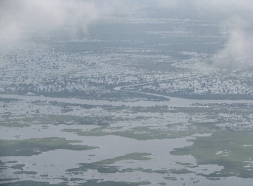

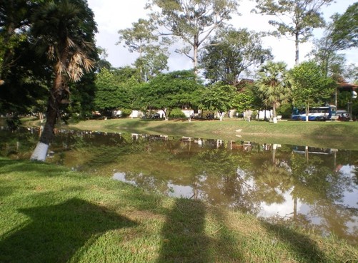
When I planned my trip, I decided to take the most tiring part of the trip at the beginning. So, after it, I could have a lot of time to relax. So, after 26 hours of flights and waiting in the airports, I landed in Siem Reap. In spite that it's the capital of its province, it is a quite small city. The city is located on the north of the Tonle Sap lake. This is the biggest lake of the South/East Asia. The lake itself is surrounded by morasses and swamps. The reason for all these damp places, is that the lake itself keeps on rising and lowering its level with the changing of the seasons. You can see the northern shore of the lake in the first picture of this group. In the second picture of this group, you can see the outskirts of Siem Reap.
The city is surrounded by a very flat land, with some small hills, that in Khmer language are "Phnom". If you want to see mountains you need to go about 30-40 km north, where you can find some of them. The arrival in the city, at the beginning, looked like going to a touristic village. The airport is very pretty. It's all new, and when we got out of the plane, a swarm of dragonflies was flying around us. It looked almost like being into a fairy-tale. I want to tell you a small information about the word "airport" in Khmer language. In fact, in Khmer the "airport" is just called "airport" as they don't have a word for it. In fact, in Khmer, the name of it should be something like "The place where land the flying ships". Anyway, this airport was very beautiful. The inside of the airport itself looks like a museum. When you step inside, you can see many real-size replicas of the statues that were found inside the archaeological park. The visa costs you 20 US dollars if you have a picture for the visa with you, and 21 if you don't have the picture. In Kampuchea you can use two currencies. The national one is the Riel, and 1000 Riels are worth about 0,25 US Dollars, while tourist can freely use the US Dollar, as it's accepted everywhere even more than the Riels. The problem is when you have to pay some US Dollar cents, as you'll have the change in Riels. So, I learnt very fast that 4000 Riels were 1 US Dollar worth. The visa can be made at the arrival in the airport or on the land-borders. The funny thing was that when it was my turn at the immigration desk, I handed to the officer a strip with two pictures in passport size. The officer told me "I want one!", I told him "Ok, take one", and he answered "I want one!", and I answered "Ok, cut them!", he answered "I want ONE!", so I replied "Ok, give me the scissors!", he replied angry "I WANT ONE!", and I replied, slowly, miming with my hand the scissors "Do you have S-C-I-S-S-O-R-S or I have to tear the pictures with my teeth?". So, he finally understood and gave me the scissors. Then I went to the next step, and I discovered that the visa-form that I had just filled was out-of-date, and I had to fill a new one. So, after this long waste of time, they let me enter Kampuchea.
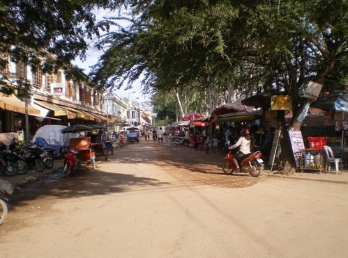
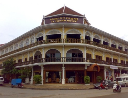
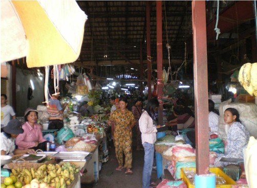
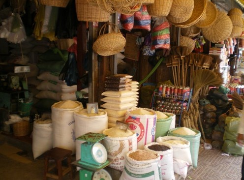
As you get out the airport, you find yourself surrounded by people that offer you taxi service. But as my experience taught to me, I preferred to go to the taxi desk and ask for a regular one. To my disappointment, they told me that although I wanted a tuk-tuk (a cart dragged by a motorbike that works as a regular taxi), I couldn't get one. In fact, the tuk-tuks were only for groups of two or more people. As I was alone, I had to take a motorbike. So, in the end I accepted to go to the centre with a motorbike-taxi. You can't imagine how it was to go with that crappy motorbike, the crazy driver, my big backpack before the driver and the small backpack on my shoulders. That was a really crazy experience. So, in about 15 minutes of crazy driving, we reached my hotel, and it cost me 2 dollars. My hotel, the Ta Prohm Hotel (you can see it in the fifth picture of this group), was wonderful. Probably the best I was ever in. The personnel were super kind and the room was great. The building is in colonial style, and I liked it so much. When I chose the hotel, I studied carefully the place. The hotel was on the "riverside" of the city (but the city is so small that every place in the centre, is not far from the riverside), and next to the "Old Market" (the place where ancient travellers and merchants were dealing goods, where now you can find many good deals), and also close to the "Pub Street", where you can find almost all of the few pubs of the city. So, I also liked the location very much. The name of the city has an interesting origin. In fact, in Khmer it means something like "the laying down Siam" or "the grounded Siam". The city was named like this in the Angkor times (about in the year 1100) after a victory in a battle against the Siamese troops (for Siam is meant the modern Thailand). In this group of pictures, you can see in the third and fourth some streets of Siem Reap, while the sixth and seventh were taken in the "Old Market". As you see, Siem Reap looks really pretty.
The city is surrounded by a very flat land, with some small hills, that in Khmer language are "Phnom". If you want to see mountains you need to go about 30-40 km north, where you can find some of them. The arrival in the city, at the beginning, looked like going to a touristic village. The airport is very pretty. It's all new, and when we got out of the plane, a swarm of dragonflies was flying around us. It looked almost like being into a fairy-tale. I want to tell you a small information about the word "airport" in Khmer language. In fact, in Khmer the "airport" is just called "airport" as they don't have a word for it. In fact, in Khmer, the name of it should be something like "The place where land the flying ships". Anyway, this airport was very beautiful. The inside of the airport itself looks like a museum. When you step inside, you can see many real-size replicas of the statues that were found inside the archaeological park. The visa costs you 20 US dollars if you have a picture for the visa with you, and 21 if you don't have the picture. In Kampuchea you can use two currencies. The national one is the Riel, and 1000 Riels are worth about 0,25 US Dollars, while tourist can freely use the US Dollar, as it's accepted everywhere even more than the Riels. The problem is when you have to pay some US Dollar cents, as you'll have the change in Riels. So, I learnt very fast that 4000 Riels were 1 US Dollar worth. The visa can be made at the arrival in the airport or on the land-borders. The funny thing was that when it was my turn at the immigration desk, I handed to the officer a strip with two pictures in passport size. The officer told me "I want one!", I told him "Ok, take one", and he answered "I want one!", and I answered "Ok, cut them!", he answered "I want ONE!", so I replied "Ok, give me the scissors!", he replied angry "I WANT ONE!", and I replied, slowly, miming with my hand the scissors "Do you have S-C-I-S-S-O-R-S or I have to tear the pictures with my teeth?". So, he finally understood and gave me the scissors. Then I went to the next step, and I discovered that the visa-form that I had just filled was out-of-date, and I had to fill a new one. So, after this long waste of time, they let me enter Kampuchea.
As you get out the airport, you find yourself surrounded by people that offer you taxi service. But as my experience taught to me, I preferred to go to the taxi desk and ask for a regular one. To my disappointment, they told me that although I wanted a tuk-tuk (a cart dragged by a motorbike that works as a regular taxi), I couldn't get one. In fact, the tuk-tuks were only for groups of two or more people. As I was alone, I had to take a motorbike. So, in the end I accepted to go to the centre with a motorbike-taxi. You can't imagine how it was to go with that crappy motorbike, the crazy driver, my big backpack before the driver and the small backpack on my shoulders. That was a really crazy experience. So, in about 15 minutes of crazy driving, we reached my hotel, and it cost me 2 dollars. My hotel, the Ta Prohm Hotel (you can see it in the fifth picture of this group), was wonderful. Probably the best I was ever in. The personnel were super kind and the room was great. The building is in colonial style, and I liked it so much. When I chose the hotel, I studied carefully the place. The hotel was on the "riverside" of the city (but the city is so small that every place in the centre, is not far from the riverside), and next to the "Old Market" (the place where ancient travellers and merchants were dealing goods, where now you can find many good deals), and also close to the "Pub Street", where you can find almost all of the few pubs of the city. So, I also liked the location very much. The name of the city has an interesting origin. In fact, in Khmer it means something like "the laying down Siam" or "the grounded Siam". The city was named like this in the Angkor times (about in the year 1100) after a victory in a battle against the Siamese troops (for Siam is meant the modern Thailand). In this group of pictures, you can see in the third and fourth some streets of Siem Reap, while the sixth and seventh were taken in the "Old Market". As you see, Siem Reap looks really pretty.
